MapBrief™

Geography · Economics · Visualization

The Tyranny of “Requirements”: Why Map Portals Don’t Work, Part III

“Why Map Portals Don’t Work” is a five-part exploration of why the dominant visual grammar of GIS interfaces serves its public audience so poorly and continues to diverge from the best practices found most everywhere else on the web. Read Part I, Part II, Part IV, Part V.  On February 27th, I will be joining James Fee for an online conversation about this series at SpatiallyAdjusted.com.

Every IT project needs requirements, right?  And “gathering” them sounds so collaborative, so collegial, and so relentlessly unobjectionable, what could possibly go wrong?

Besides your map portal project coming in late, over budget, and largely unusable? Nothing.  Nothing at all.

Because if you are building any public-facing interface you have exactly four requirements:

FAST  •  INTUITIVE  •  INFORMATIVE  •  FAST

Be clear on this single fact:  you are competing for User Attention.  On the Internet.  You don’t get to set the rules.

But look on the bright side:  you don’t have to write up Help documentation because normal people don’t read Help documentation. If they can’t figure out what to do—quickly—they simply you leave your site.  The web is full of other interesting content that doesn’t need to be puzzled over.

The Vicious Cycle of Bloat

Buying into the feature-laden, layers-upon-layers map portal paradigm quickly kicks off a vicious Cycle of Bloat.  First, the portal gets a full menu of default features intended to serve both internal users as well as the general public.  As layers and tools get added, it becomes necessary to hire a consultant/developer.  OK, now our map portal is officially a Project.  With your hired gun and extra coding fu at your disposal, adding a few more in-house edge cases doesn’t seem like a big deal (after all, you’re getting more value from your outside resource).  And its Middle Management 101 to reach out to other departments to bring them on board if only to be able to spread the reputational blame around should things not work out as planned.

Too Many Engineers Spoil the UX

Playing a critical role in the Cycle of Bloat is our Engineering brethren.  Specifically the subset of engineers who generously broadcast their technical criticisms with a cross-armed petulance gloriously liberated from ordinary self-awareness.  That guy (yes, it’s always a guy), has his own laundry list of features—in-browser feature editing tools, map-composing options, and of course “print-to-plotter” are perennial favorites—without which he’ll unilaterally and loudly declare the whole thing a waste of money.  All because of the obscure need for the map portal to do exactly what the $23,000 of technical software installed on his workstation already does.

The Power of No

The journey to clean, simple map interfaces geared towards the general public doesn’t start with a first step.  It starts with a simple word.

No.

Saying “no” to the premise of a single map portal serving both internal users and the general public is the prerequisite to building anything that will meet the four non-negotiable criteria stated above.  As someone famous once said, you can’t serve two masters—and neither can your map portal.  Stop trying to build the mythical interface that’s all things to all people and you might just be able to pull off something that is worth the valuable time of your general users.


—Brian Timoney


* top photo courtesy of  Loren Javier’s Flickr stream
** chefs photo courtesy of Wikimedia


Paralysis of Choice: Why Map Portals Don’t Work, Part II

“Why Map Portals Don’t Work” is a five-part exploration of why the dominant visual grammar of GIS interfaces serves its public audience so poorly and continues to diverge from the best practices found most everywhere else on the web. Read Part I, Part III, Part IV, Part V.  On February 27th, I will be joining James Fee for an online conversation about this series at SpatiallyAdjusted.com.

Who doesn’t like choice?

What consumer doesn’t want 11 flavors of Special K, the 200 tasty dishes the Cheesecake Factory serves up, or the all-you-can-eat bliss of Golden Corral?

No one.  Or at least no one I care to associate with.

Turns out there are some folks with PhDs (probably don’t go to Golden Corral) who have discovered that too many choices are psychologically debilitating and make people less happy (cue the TED talk).

So yeah, your map portal has too many layers, leaving your users psychologically debilitated and unhappy.

Like most of the usability problems of map portals, this default reflex can be traced to the web 1.0 legacy idea of GIS-in-a-browser where the ideal was importing as much of the visual grammar of desktop GIS interfaces as a browser could support.  Which worked fine…for those who worked with GIS interfaces on a daily basis.

Central to the GIS experience is the ability to determine relationships between different types of features–loaded in as “layers”–and being able to, say, calculate the number of properties within a flood plain. The more layers one has on hand, the more possibilities for exploring multivariate relationships, etc.

Turns out the general user doesn’t have a whole lot of use for exploring multivariate relationships. No, they are searching for a particular piece of information–their tax assessment (and their neighbor’s), the nearest rec center’s hours, a property’s zoning status, etc.

Problem: Multiple map layers make it difficult to elicit a user’s intent and vastly overestimate the public’s interest in figuring out how to manipulate the map display.

That’s why the City of Denver has found single-topic maps get more than 3x the usage of their portal.  And Pareto’s principle is very much in force:  80% of your users are interested in a small handful of use cases. So build your simple single-topic maps to address the most common use cases:  property lookup, parks, crime, polling places, et al.

But what of the 20% who do want to interact more deeply with more data?

If your organization is of the Open Data persuasion (and it should be), then you have it easy.  Because in 2013, engaged general users who are comfortable with map interfaces have Google Earth already downloaded.  Provide a simple KML link and send them on their way.

Now we’re down to the 3-5% of hardcore users who need shapefiles–let ‘em have shapefiles so they can happily go GIS-ing in ArcMap, QGIS, gvSIG, et al.

But let’s be clear: slapping all of your layers on a single interface to placate the most demanding 3-5% of your audience sabotages the user experience of the vast majority.

Or Build Your Own, Better Basemap

We are in the dawn of a New Golden Age of Cartography.  One of its hallmarks is that now we can create our own basemaps, or exert fine-grained control over 3rd party map tiles.  A great example of this fresh approach is the National Park Service’s “Park Tiles” project which manages to integrate 13 layers of information into a clean, intelligent basemap.

Cures for Layerrhea:  a) break out most important layers into single-topic maps; b) provide data downloads for power-users; c) roll your own basemap with supporting, contextual layers baked-in.


—Brian Timoney

**Image above courtesy of the BLM

Coming Soon: Stop ‘Gathering Requirements’


Why Map Portals Don’t Work – Part I

“Why Map Portals Don’t Work” is a five-part exploration of why the dominant visual grammar of GIS interfaces serves its public audience so poorly and continues to diverge from the best practices found most everywhere else on the web. Read Part II, Part III, Part IV, Part V.  On February 27th, I will be joining James Fee for an online conversation about this series at SpatiallyAdjusted.com.

It’s been six months since my most popular post How the Public Actually Uses Local Government Web Maps: Metrics from Denver; I’ve been gratified by the feedback.  But despite laying out detailed metrics showing that single-topic maps garner 3x the traffic of traditional portals, that user-friendly text search is critical to the map experience, and that users don’t spend time fiddling with default viewer parameters, I’ve found two particular reactions troubling:

  • No one has widely circulated their own web metrics that shine a more positive light on map portals.
  • People still keep building public-facing map portals. And writing press releases about them.

            The road to mediocre web experiences is paved with good intentions


For the next few posts, then,  we’ll lay out some major drawbacks of standard web portals as well as suggest a few alternatives along the way.  While the baseline scenario I have in mind are public-facing government mapping portals, those rolling corporate intranet solutions would do well to take heed.

Problem #1: Map Portals Over-Focus on the Map, Under-focus on Text-Based Search and Discovery

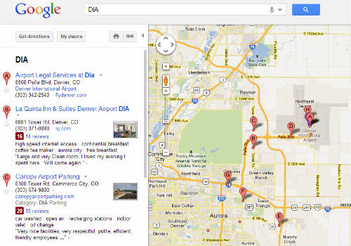
The dominant finding from Denver’s metrics is that the public approaches maps to retrieve particular bits of information, and then leave.  And how does everyone do Search & Discovery?  Think of your favorite search engine: you start typing into an auto-suggest box, then you get a text list of possibilities.  Both Google Maps and Bing Maps use a similar visual grammar–search text-box across the top, listings on the left, map on the right.

            Users are familiar with a map that contextualizes text-based search


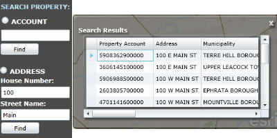
GIS people all-too-easily lose sight how unfamiliar map navigation is for the general user, especially when confronted with an “immersive” experience.  The text box, then, featured prominently and with auto-complete, is a life-raft of familiarity.  Contrast that to this typical setup that we find in the Lancaster County GIS Property Search site:

          Ye shall be known by your Property Account number


The search box is on the left side of the map, with Account search separate from Address search.  OK, what’s an Account number? Address is familiar, but why is House Number separate from Street Name?  Because, as we can all guess, that’s how it’s stored in the database.  And none of this is auto-complete, so my address-lookup is really an address-guess.  Being a clever sort, I enter “100” “Main” and get 15 possibilities popping up in a Results window on the other side of the map. And only two fields are clearly visible, the Property Account and the Address (which I already entered).  Now this business with the Account number being featured so prominently is starting to make me wonder if this site is really meant for the public or the clerks in the Assessor’s Office who work with Account numbers all day long.  Finally, instead of plotting the properties in the map as obvious, clickable placemarks, they’re rendered as polygons, which, at the zoom level necessary to encompass all 15 possibilities, makes them barely visible.  Which I figured out when I went to remove a smudge from my monitor.

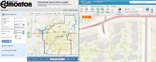
We’re not pointing fingers at Lancaster County here, because these are the same choices GIS people inflict on the public every day: unfamiliar interface layouts, text fields that don’t auto-complete, and results windows that pop up in other parts of the screen.

Takeaway #1: Users Want and Need a Large, Obvious, Auto-Complete Text Box to Drive Search & Discovery


Coming Soon: All Those Layers are Getting in the User’s Way


—Brian Timoney