MapBrief™

Geography · Economics · Visualization

PostGIS Is So Successful That It Needs To Change Its Name

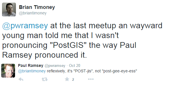
Like all important debates of our time, this one started with a tweet:

I’m no branding expert (I don’t spend nearly enough money on my haircuts), but it seems to me that if your name includes a specific acronym–“GIS”–perhaps you should pronounce it the way the acronym itself is pronounced.  And while we’re on the topic, how obvious is it to the newcomer that the “Post” relates to the PostgreSQL database?

Don’t get me wrong: I love PostGIS, even to the extent of co-organizing an upcoming “PostGIS Day” here in Denver.  But even at the risk of losing an amusing pun on “GIS Day”, one thing is now crystal clear to me–

PostGIS is so successful it needs a new name.

First, the name recognition of PostgreSQL has increased enormously in recent years:  from only Geek Cred to now widespread Street Cred.  So we need to make that association more explicit.

Then we have the acronym “GIS”.

It needs to go.

The assumption that those who would find a spatially-enabled database useful in 2015 would be familiar with “GIS”–either by education or professional practice–is much too narrow.  And while those of us who have earned our chops via GIS courses and years of desktop software may cringe inwardly, the obvious reality is that increasing numbers of bright and talented people who want to do mappy things and geo-analysis things don’t naturally connect such desires with “GIS”.

So I beseech the caretakers of this extremely valuable piece of open-source geospatial software to choose a new readily- identifiable moniker that captures its dynamic centrality in the ever-evolving mapping industry.

Brian Timoney is an information consultant in Denver, Colorado.


JS.Geo: Web Mapping at a Crossroads, and the Crossroads is in Philadelphia on October 8th

Web maps are too important to be left to the mapping industry.

Google figured this out before anyone else. Uber’s recent purchase of Microsoft’s Bing Maps assets and the sale of Nokia HERE geo assets to an automobile consortium signal next-level dynamism in the industry. Simply put, the old web mapping portal paradigm of GIS-in-the-browser doesn’t cut it in the emerging mobile-driven, ever-more-automated, on-demand economy (and never really did).

FINAL 25 TICKETS GO ON SALE THURSDAY AUGUST 13th, 12PM EDT/10AM MDT

 
This fast-changing environment needed a different kind of conference.

Nix “conference”, let’s say “get-together”. Chris Helm, Steve Citron-Pousty, and I created JS.Geo to focus on Javascript & mapping and get those who solve the problems and write the code in the same room. Leave the sales deck at home, talk honestly about what works/what doesn’t, link to a Github repo, and enjoy being around people who aren’t people who enjoy being at conferences.

FINAL 25 TICKETS GO ON SALE THURSDAY AUGUST 13th, 12PM EDT/10AM MDT

So on October 8th we’re doing the 3rd iteration of JS.Geo in Philly with a jam-packed lineup to discuss what’s urgent: vector tiles (vs raster tiles), 3D tiles (and no, not your weak-tea 2.5D tiles), in-browser spatial analytics/advanced computation, mobile collection, indoor mapping, etc. More than just tech, we’ll hear from practitioners who have to deliver value to citizens, customers, and readers of online journalism.

You know, the actual user experience.

We keep the admission modest–under $25–and that only happens because our sponsors understand the value proposition of putting their smart people around other smart people and provide the necessary financial support.

Check them out: Azavea, Cesium, Fulcrum, Zekiah, Bright Rain, IBM Mobile First, and Mapzen.

Join us.

FINAL 25 TICKETS GO ON SALE THURSDAY AUGUST 13th, 12PM EDT/10AM MDT

JS.Geo at a glance:

  • Thursday, October 8th
  • University Science Center, Philadelphia (walking distance from Amtrak 30th Street Station)
  • Presentations 9:15AM – 4:30PM
  • Social 4:30PM – 6PM
  • **LocationTech will be co-locating an evening tour event
  • Probability of late night run to  9th Street cheesesteak mecca = 0.999


Mapquest + Mapbox: A Win-Win With A Huge Unanswered Question

In a rare confluence of a languid blogging pace with the tempo of events, my last post on the Verizon purchase of Mapquest was quickly followed by news that Mapquest would be contracting out its map rendering to the high profile start-up Mapbox.  No real follow-up has come out of either camp, including silence from the otherwise prolific Mapbox blog.  But as nature abhors a vacuum, I’ve independently verified the broad strokes of the deal so will happily offer my speculations in the absence of mere facts.

Here’s what each side wins:

Mapquest gets to move fast on a more mobile-centric strategy on the back of the recently launched Mapbox Mobile SDK.  Ditto for being to tap into Mapbox’s work with OpenGL, streaming vectors, and integrating cloud-based DevOps with map usage analytics. And, presumably, an overdue refresh of the Mapquest cartographic style.

But this isn’t a wholesale hollowing out of a brand: Mapquest is keeping its Routing capability in house. Especially in the context of an economy that’s increasingly reliant on-demand logistics, routing is now “hot” again as the ability to adjust routes on-the-fly to real time dynamic conditions is now a competitive necessity for the enterprise.

And should you still be dismissive of Mapquest’s prospects, you can always browse their patent portfolio which makes for interesting reading.

In short: Verizon muscle + Mapbox sexy are a promising combination for a Mapquest resurgence.

Mapbox gets its wares in front of Mapquest’s 40 million unique monthly visitors and an important validation of its vision of being “the map layer for the Internet”.  Funding the next stage of growth won’t be a problem.  Working with TomTom data (the Mapquest provider in the US) will be helpful with potential clients who view the company’s reliance on OpenStreetMap with a degree of skepticism.


The Billion Dollar Question

Who gets access to Verizon’s mobile location data?

As I mentioned in my last post, “noisy” geotagged mobile data in aggregate becomes very valuable, both as behavioral as well as spatial data.  Verizon already sells aggregated/anonymized customer data to 3rd parties, so giving subsidiaries and partners a taste would make sense.

With the rationale of Verizon’s purchase of AOL being “ad tech”, being able to weave in customer location behavior would be a slam dunk for Mapquest.


But will Mapbox be able to get its hands on the Verizon trove?

Good question. But Mapbox CEO Eric Gunderson understands the value of a user data feedback loop:

“Nokia HERE is just doing it wrong,” he says of how the company’s mapping division,  now up for sale, constructs its dataset. “They are spending over a half a billion dollars a year driving cars around and processing that data. That was how you made a map 10 years ago — like back when you had these little Nokia dumb phones. These guys don’t understand the idea of building for mobile and building tools for developers — if they did they would be able to get real time data streams back and have a better map.

As a vocal proponent of OpenStreetMap, it’s tantalizing to think of the boost in quality to OpenStreetMap in the US should Mapbox have access Verizon data streams and be able to put derived data of higher quality back into the commons.  A couple of problems with that vision are a) Verizon could rightly see those derived products as a competitive advantage to be kept in-house and b) the licensing issues around OpenStreetMap continue to be thorny.

For Mapbox and others heavily on reliant on OpenStreetMap, their tech will only be as cool as the quality of data behind it.  Consider Mapbox’s recently launched Bicycle Directions:

Now ponder the possibilities of enriching the directions with data streams of where people actually bike?

So, yeah, data feedback loops are critical because you don’t get a second chance after sending a user into an irrigation ditch.

*  *  *  *  *  *  *

Both Mapquest and Mapbox will immediately benefit from the announced collaboration.  But whether the much bigger prize of Verizon’s mobile location data stream will be seized, and by who, is what’s worth keeping an eye on.


Brian Timoney is an information consultant in Denver, Colorado.
 

woman working out photo courtesy of Rikard Elofsson’s Flickr stream
elephant in the room photo courtesy of David Blackwell’s Flickr stream