MapBrief™

Geography · Economics · Visualization

Web Mapping Continues to Pay for the Sins of Internet Explorer

So how have you been celebrating the 5th anniversary of the launch of Internet Explorer 7? For tens of thousands of public sector folk here in the US, they celebrate everyday as IE 7 is the only browser they are allowed to use on the job*. For comparison’s sake, the best-selling mobile phone in 2006 was the Nokia 1600. Now imagine if every mobile app had to be backwards compatible with the most popular cellphone of 2006?

And now you being to understand the rage web developers feel towards Internet Explorer versions 6-8 and the thousands of programming hours spent weekly accommodating their quirks and the 20-25% market share they continue to hold on to in 2011.  And knowing that the more standards-compliant alternatives, Firefox, Chrome, and Safari, are freely downloadable makes the despair all the more wail-inducing.

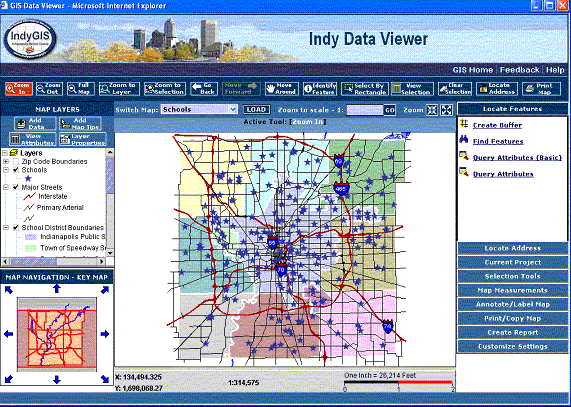
         Contemporary web mapping continues to be haunted by the GIS-in-a-browser approach


The cool kids, of course, don’t give a thought to those left behind in IE-land and happily embrace the HTML5 future. But we in the mapping world have no such luxury as the very entities most likely to be using retrograde browsers are the traditional users of GIS (read: guv’ment). So there was a big embrace of Flash and Silverlight plugins as cross-browser “solutions”, whose viability ended when Apple decreed no plugins on the iPhone and iPad. The inside joke is that “RIA”, the self-designated acronym for “Rich Internet Application” now stands for “Rich Intranet Application.”

Now let’s indulge in a bit of counter-factual fantasy: it’s August, 2001 and Microsoft announces the launch of Internet Explorer 6 that will support Scalable Vector Graphics (SVG), a W3C standard for drawing vectors in the browser using ordinary mark-up inside an HTML page. Because of performance limitations, the maps made with SVG are limited in the number of features displayed, but nonetheless we start seeing lots of choropleth (thematic) maps especially on election night. Further, the visibility of SVG mark-up via the trusty “View Source”  command enables non-programmers to copy professional examples and make their own web pages with custom maps. Personal online diaries, subsequently called blogs, start embedding their own maps and the democratization of cartography gathers even more momentum.

None of this happened.

Instead, Microsoft foisted its own preferred standard–VML–and web mapping remained strictly the province of “heavy” server-centric solutions until Google Maps and the mashup revolution kicked off in 2005. With its predilection for over-engineered GIS-inside-a-browser apps, the industry combined evolving server resources with plugins (Flash, ActiveX, Silverlight) to push large volumes of both raster and vector data via interfaces that even today way too many users find bewildering. A side-effect of the industry embracing complex apps is that in too many shops, web mapping became the province of the hired consultant, with the GIS Analyst shunted aside for lack of programming chops. Recent online make-a-map services such as GeoCommons, Google Fusion Tables, and ArcGIS Online are a much-needed re-empowerment of the non-programming web mapper.

In future posts I’ll highlight two new-ish mapping approaches to bridge the worlds of Internet Explorer and the iPad:  MapBox and Raphael.js. But in the meantime, while the techno-optimists invoke William Gibson and a future that’s already here, just unevenly distributed, I fear we in the geospatial realm are more haunted by William Faulkner’s observation that “the past is never dead. It’s not even past.”

 
—Brian Timoney

*Currently the case with my beloved City & County of Denver.  Colleague Bill Dollins speaks of DoD shops still using IE 6. Quelle horreur.
Among America’s Best & Brightest, Geography Casts But a Faint Glow

Proust had his madeleine, the rest of us have our parents’ basements and attics with the bric-a-brac that promises emotional transport to a different time and place. During my last visit home, I came across my grandmother’s diploma circa 1914: a fascinating document from an era where a couple years of high school was the terminus for her social class and a quite adequate preparation for being a seamstress, clerk, or housewife (the professions of her and her sisters).  Most interesting, the diploma listed the courses she took: catching my professional eye were entries for both Physical Geography and Political Geography.

In other words, two more geography courses than her grandson took in his “college prep” curriculum seventy years later.

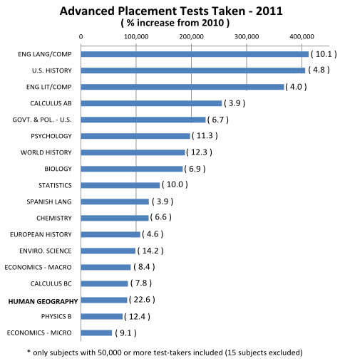
Being curious as to what the kids are up to today, I delved into the Advanced Placement (AP) test data for 2011 to find out “whither Geography among our best and brightest?”  While the rigorous International Baccalaureate curriculum has gained traction in recent years, AP courses are more numerous and their test scores, which can command college credit, provide a hefty sample size from which to draw conclusions.


The good news?  Among subjects with more than 50,000 test-takers, Human Geography had the largest year-over-year increase with a healthy 22.6% bump to almost 84,000 students undergoing the 2-hour ordeal.

The bad news?  More than twice as many young American minds sat for the AP Psychology test.

(Editor’s note: pondering for more than 30 seconds what may lurk inside a high school Psychology text book plunges the author into existential despair.)

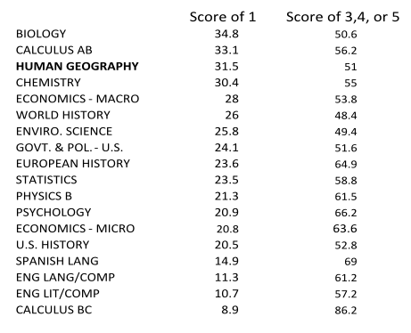
But that’s not the worst news. Because on a scale of one to five, over 31% of those taking the exam scored a “1” i.e. utter failure. Adding to the ignominy, a bare majority of 51% scored a passing grade of 3, 4, or 5.


Taking a closer look at the scores and their distributions, one can make the broad claim that results in the social sciences are fairly mediocre.  To be sure there is a selection bias at work as well: completing the coursework for Calculus BC implies mastery of the material in Calculus AB, and the scores reflect that very few bumble through that progression.  (Full disclosure: I was one of those bumblers racking up a “2” in AP Biology many moons ago.)

Cause for hand-wringing despair?  Maybe not.  More plausible to me is the suspicion that for those taking AP Human Geography as a junior or senior in high school, it’s most likely their first exposure to thinking geographically in any kind of a structured manner. If anything, it’s a call for more rigorous geography at all grade levels as analyzing one’s place in the world and the interrelationships with those near and far is too important to leave to a cram course at the end of high school.

Add that to the wisdom lost from back in Grandmom’s day that we so need to recover, 100 years later.

 
—Brian Timoney


GIS, IT, and the Interests Served by a Dysfunctional Status Quo

Last week I had the pleasure of speaking at the FOSS4G Conference here in Denver, Colorado.  As has been noted elsewhere, it was a high-energy event loaded with quality technical content. With a time slot at the end of the day, I sought to change gears and speak about the role the cultural values of open source might play in an industry whose best work is too often stifled by bureaucratic intransigence and the narrow interests of entrenched vendors. While I’m proud that the vast majority in my industry are committed professionals who want to do right by their users, I am both puzzled and angered that so many projects we put in front of the public, after millions of dollars spent, fall far short of expectations.


A pleasant surprise in the aftermath of the talk was being approached by folks from the very agencies I had “called out” and being thanked for shining a modest light on the dysfunction they have been wrestling with for years. Just to be clear, the projects I highlighted weren’t chosen for being particularly egregious, but rather for being all-too-typical.

As the open source model gains traction in the geospatial industry, much ink is being spilled discussing key issues such as total-cost-of-ownership, support, security, etc.  Such scrutiny is all to the good, especially if accompanied by an equally open conversation of the benefits and costs of the status quo that all too often fails to serve users and practitioners alike.


—Brian Timoney